How ParcelMap BC is Maintained
Contents
ParcelMap BC data is continually updated by the ParcelMap BC Operations team. New plans and other parcel fabric updates enter the maintenance queue upon registration or confirmation, with an updated publication service target of approximately two business days.
How Survey Plan Datasets are Used to Update ParcelMap BC
The ParcelMap BC fabric is continually updated using the best authoritative sources, including event triggers and attributes direct from the land title register for completeness. Attributes on titled parcels, Crown land parcels and the Crown land registry are also included. Spatial representations are maintained based on digital Survey Plan Datasets submitted by land surveyors based on the legal plan filings as required by the Surveyor General.
The ParcelMap BC Operations team follow defined procedures based on operational assessments when integrating a Survey Plan Dataset to update ParcelMap BC. Two join techniques are possible for this integration, depending on the fit of the new survey data in relation to the existing parcel fabric’s location and shape.
Regardless of which technique is performed, the survey dimensions and ties to control points reflecting the survey plan – as supplied by the land surveyor in the Survey Plan Dataset – are always preserved in ParcelMap BC to support future Spatial Improvements.
Comments from a ParcelMap BC Adopter
“I am incredibly happy with the ParcelMap BC dataset. I have been able to leverage the data for both internal use as well as for our customer-facing webmap.”
Rheannon, City of Prince Rupert
Type 1 Join: Fit Survey Plan Dataset to Existing Parcel Data
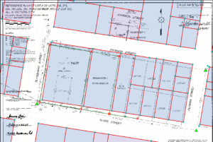
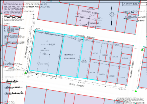
In the scenario where a Survey Plan Dataset is to be integrated to ParcelMap BC where the location and linework of the incoming survey spatially aligns (within measured tolerance) with the existing parcel fabric, a Type 1 Join will generally be performed. This scenario occurs when the existing parcel fabric is of high quality, such as where there was a previously integrated Survey Plan Dataset or where survey dimensions for the parcels were manually captured in the fabric from a survey plan. A Type 1 Join results in the Survey Plan Dataset being fit to the location of existing parcel points such that the shape and location of the existing parcel representations are preserved. See figures below for the representation of the parcel fabric before and after a Type 1 Join.
Type 1: Pre-Join
The incoming Survey Plan Dataset (green lines) closely aligns with the shape and location of the existing underlying parcel fabric (red lines).
Type 1: Post Join
Linework for the incoming Survey Plan Dataset have snapped to fit the underlying parcel fabric (red lines), as indicated by the highlighted blue lines.
View a video demonstration on a Type 1 Join
Type 2 Join: Update Parcel Data to Fit Survey Plan Dataset
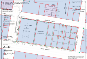
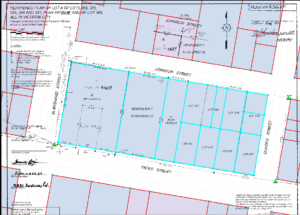
In the scenario where a Survey Plan Dataset is to be integrated to ParcelMap BC and the location and linework of the incoming survey does not spatially align with the existing parcel fabric, a Type 2 Join will generally be performed. This scenario generally occurs when the location and/or shape of the existing parcel fabric is of lower or uncertain quality, such as for parcels where the location and survey dimensions were inversed from stakeholder supplied sources during the initial build of ParcelMap BC. A Type 2 Join results in the location and shape of the Survey Plan Dataset being held fixed and the existing parcel points being fit to the corresponding points in the new survey. Consequently, the shape and location of the incoming Survey Plan Dataset is preserved and those of the underlying parcels are updated. See figures below for a representation of the underlying parcels before and after a Type 2 Join.
Type 2: Pre-Join
The existing underlying parcel fabric (red lines) does not spatially align with those of the incoming Survey Plan Dataset (green lines).
Type 2: Post Join
The highlighted blue lines indicate where existing parcel fabric (red lines) has snapped to fit the shape and location of the incoming Survey Plan Dataset. The underlying fabric parcels are neatly aligned to the new survey.
View a video demonstration on a Type 2 Join
How Spatial Improvements Evolve ParcelMap BC Accuracy
To improve parcel fabric quality and integrity, spatial improvements in ParcelMap BC are used to update both the relative and absolute positioning of survey parcels and to improve the accuracy of the mapped parcel representations.
Spatial improvements can range from simple transformations that only improve absolute positioning (not relative accuracy) through to rigorous least-squares adjustments that involve a full survey network adjustment of both relative and absolute position.
Additional Assistance or Data Issues
If you notice a data discrepancy in ParcelMap BC, please send the PID / PIN and plan number of the affected parcels and a screenshot of the area to allow us to better assist you.
Online inquiries can be sent to myLTSA Tech Support at ParcelMapBC@ltsa.ca or call:
Greater Vancouver area: 604-630-9630
Elsewhere in BC, Canada and the US: 1-877-577-LTSA (5872)